Section 1: The Problem
Illegal logging happens far from the people responsible for stopping it. Roads can be cut into remote forests, valuable trees removed, and temporary trails hidden by regrowing vegetation before an inspector ever arrives. INTERPOL estimates that illegally logged timber is worth between $51 billion and $152 billion each year and represents roughly 15% to 30% of global timber trade (INTERPOL).
The damage extends beyond stolen wood. Illegal logging removes government tax revenue, undercuts legal timber companies, destroys habitat, and can strengthen organized criminal networks. In some countries, illegal activity accounts for as much as 90% of logging, while communities that depend on forests lose resources and control over their land (World Bank).
Traditional enforcement depends on patrols, permits, field inspections, aircraft, and analysts manually comparing satellite images. Those methods remain essential, but tropical forests are enormous and clouds regularly hide activity. By the time an enforcement team learns where logging occurred, trucks may already be gone.
Section 2: What Research Shows
High-resolution satellite imagery and machine learning make small disturbances easier to find. Dalagnol and colleagues trained a U-Net model on 73,744 labeled Planet NICFI image patches from Mato Grosso, Brazil. On validation imagery, the model detected logging with 90% recall, 75% precision, and an F1 score of 0.82 (Dalagnol et al.).
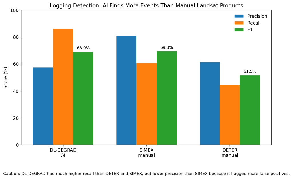
The more revealing comparison came against operational monitoring systems. Using independent reference samples, DL-DEGRAD found 86.2% of logging disturbances. The manually interpreted SIMEX product found 60.7%, while Brazil’s DETER logging product found 44.3%. DL-DEGRAD’s F1 score was 68.9 compared with 69.3 for SIMEX and 51.5 for DETER, showing that automation dramatically increased recall but also generated more false positives (Dalagnol et al.).
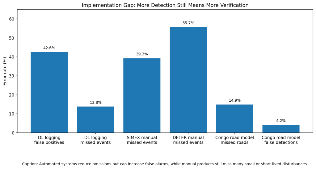
Newer systems can find logging infrastructure at continental scale. Slagter and colleagues combined Sentinel-1 radar, Sentinel-2 optical imagery, and deep learning to map Congo Basin forest roads monthly. Their model reached an F1 score of 0.909, with a 4.2% false-detection rate and 14.9% missed-detection rate (Slagter et al.). A 2026 review of 65 peer-reviewed tropical forest monitoring studies concluded that AI can greatly expand automated monitoring, but transferability, training data, cloud cover, computing capacity, and local validation remain major barriers (Gizachew).
Section 3: What the Real World Shows
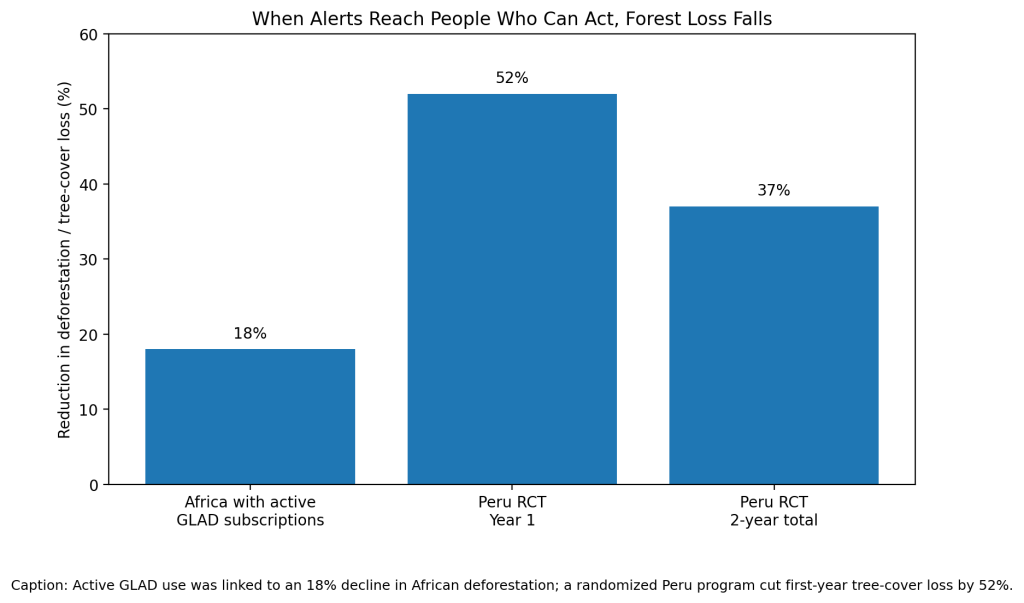
Detection matters only when someone acts on it. Moffette and colleagues studied subscriptions to free Global Land Analysis and Discovery, or GLAD, alerts across 22 tropical countries. In African areas where users actively subscribed to alerts, the probability of deforestation fell 18% relative to pre-alert averages. The researchers estimated avoided carbon damages worth $149 million to $696 million (Moffette et al.). Simply making the alerts available, however, did not significantly reduce deforestation (Moffette et al.).
An even stronger field test came from the Peruvian Amazon. Slough, Kopas, and Urpelainen randomly assigned a satellite-assisted community monitoring program to 39 of 76 Indigenous communities. Local monitors received monthly forest-loss alerts, used smartphones to locate threats, and conducted paid patrols (Slough, Kopas, and Urpelainen).
During the first year, monitored communities lost 8.4 fewer hectares of tree cover on average—a 52% reduction compared with control communities. Across both years, the estimated reduction was 37%. Effects were largest in high-risk communities, where first-year monitoring was associated with 22 fewer hectares of tree-cover loss (Slough, Kopas, and Urpelainen). The estimates carried wide confidence intervals, so the authors stressed that replication was needed.
Section 4: The Implementation Gap
The first problem is false alarms. DL-DEGRAD’s logging recall of 86.2% meant it missed relatively few disturbances, but its 57.4% precision meant roughly 43% of logging detections were commission errors. Sending inspectors to every alert would waste scarce field resources (Dalagnol et al.).
Manual systems have the opposite problem. SIMEX missed 39.3% of logging disturbances in the reference sample, while DETER missed 55.7%. Researchers found that many omissions involved small-scale logging, disturbances without obvious roads, or forest signatures that disappeared quickly as vegetation recovered (Dalagnol et al.).
The second problem is legality. A satellite can detect a new road, canopy gap, or logging deck, but that does not prove a crime occurred. Slagter and colleagues mapped 35,944 kilometers of Congo Basin road development between 2019 and 2022 and estimated that at least 78% was related to industrial selective logging. Investigators still need concession boundaries, permits, ownership records, and field evidence to determine whether the logging was lawful (Slagter et al.).
The final barrier is getting information into the right hands. The Peru researchers noted that high-frequency alerts often failed to reach frontline communities in time to deter forest loss. Even in their supported program, only 36 of 39 treatment communities ultimately participated, with safety and local conditions blocking implementation in some locations (Slough, Kopas, and Urpelainen).
Section 5: Where It Actually Works
Satellite monitoring works best when alerts trigger a defined response. In Peru, the technology was paired with trained local monitors, monthly patrols, smartphones, compensation, and community authority. Monitoring efficiency improved over time: the number of reports doubled during the first year even though patrol distance did not increase, suggesting monitors became better at locating disturbances (Slough, Kopas, and Urpelainen).
The African evidence tells the same story at a larger scale. Alert availability alone produced little measurable change, while active subscriptions in places with enforcement capacity reduced deforestation. Data mattered because somebody could do something with it (Moffette et al.).
Section 6: The Opportunity
The opportunity is not a satellite that declares someone an illegal logger. It is a faster chain from disturbance to investigation. Models can identify unusual roads and canopy loss within huge forests, rank alerts by confidence, connect them with permit and concession databases, and send the most urgent locations to communities or enforcement teams. The strongest evidence suggests the technology works when remote detection and local capacity are built together—not when another map is simply added to a government website (Moffette et al.; Gizachew).
References
[1] INTERPOL. “Forestry Crime.” INTERPOL, 2026.
[2] World Bank. Justice for Forests: Improving Criminal Justice Efforts to Combat Illegal Logging. World Bank.
[3] Dalagnol, Ricardo, et al. “Mapping Tropical Forest Degradation with Deep Learning and Planet NICFI Data.” Remote Sensing of Environment, vol. 298, 2023, article 113798.
[4] de Souza Filho, J. S., et al. “Mapping Selective Logging in the Amazon with Artificial Intelligence and Sentinel-2.” International Archives of the Photogrammetry, Remote Sensing and Spatial Information Sciences, vol. XLVIII-3, 2024, pp. 121–126.
[5] Slagter, Bart, et al. “Monitoring Road Development in Congo Basin Forests with Multi-Sensor Satellite Imagery and Deep Learning.” Remote Sensing of Environment, vol. 315, 2024, article 114380.
[6] Moffette, Fanny, Jennifer Alix-Garcia, Katherine Shea, and Amy H. Pickens. “The Impact of Near-Real-Time Deforestation Alerts Across the Tropics.” Nature Climate Change, vol. 11, 2021, pp. 172–178.
[7] Slough, Tara, Jacob Kopas, and Johannes Urpelainen. “Satellite-Based Deforestation Alerts with Training and Incentives for Patrolling Facilitate Community Monitoring in the Peruvian Amazon.” Proceedings of the National Academy of Sciences, vol. 118, no. 29, 2021.
[8] Stahl, Amanda T., et al. “Automated Attribution of Forest Disturbance Types from Remote Sensing Data: A Synthesis.” Remote Sensing of Environment, vol. 285, 2023, article 113416.
[9] Gizachew, Belachew. “Artificial Intelligence and Machine Learning in Remote Sensing for Tropical Forest Monitoring: Applications, Challenges, and Emerging Solutions.” Remote Sensing, vol. 18, no. 8, 2026, article 1193.
[10] Hethcoat, Matthew G., et al. “A Machine Learning Approach to Map Tropical Selective Logging.” Remote Sensing of Environment, vol. 221, 2019, pp. 569–582.


Leave a Reply