Section 1: The Problem
Some archaeological sites are not missing because people forgot where to look. They are missing because forest, soil, erosion, modern farming, and centuries of change have hidden them from view. Traditional archaeological survey depends on people walking terrain, cutting through vegetation, recording mounds, and deciding which bumps in the ground are natural and which were built by humans.
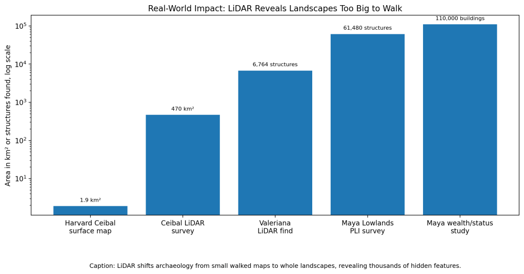
That works, but it is painfully slow. At Ceibal in Guatemala, Harvard archaeologists in the 1960s completely mapped only about 1.9 square kilometers on foot. A later LiDAR survey covered 470 square kilometers around the same region, showing how much bigger the archaeological landscape was than traditional mapping could reasonably capture (Inomata et al.).
LiDAR changes the scale. Airborne lasers can penetrate forest canopy and generate detailed elevation models, exposing old platforms, roads, terraces, reservoirs, causeways, and plazas. But a laser map is not the same as archaeological proof. It creates thousands of possible features that still need interpretation, dating, and ground verification.
Section 2: What Research Shows
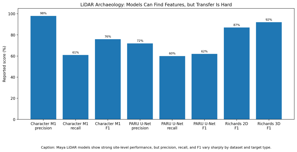
Machine learning can help archaeologists sort LiDAR features faster. Britton and colleagues summarize multiple Maya LiDAR detection studies and show how performance varies by dataset, model, and target type. In one study, Character et al.’s Model 1 reached 0.98 precision, 0.61 recall, and 0.76 F1, while Model 2 reached 1.0 precision, 0.49 recall, and 0.66 F1. That means the model was careful when it made detections, but it still missed many real structures (Britton et al.).
Richards-Rissetto and colleagues performed better on a smaller, more controlled area at Copán. Their hillshade-derived 2D model reached 0.88 accuracy, 0.85 precision, 0.89 recall, and 0.87 F1. Their 3D point-cloud model improved to 0.95 accuracy, 0.91 precision, 0.94 recall, and 0.92 F1 (Britton et al.).
The pattern is clear. Models can work very well in places where training data, terrain, architecture, and survey conditions are familiar. They struggle more when archaeologists ask them to generalize across regions, vegetation, building styles, and preservation conditions.
Section 3: What the Real World Shows
The biggest real-world win is scale. In Guatemala, the PACUNAM LiDAR Initiative mapped more than 2,000 square kilometers of Maya lowlands and identified 61,480 ancient structures, including houses, palaces, ceremonial centers, pyramids, roads, and agricultural features (Canuto et al.).
LiDAR also changes what counts as a “new discovery.” In 2024, researchers identified the hidden Maya city of Valeriana in Campeche, Mexico, using high-quality airborne LiDAR data collected years earlier for a forest monitoring project. The dataset covered about 122 square kilometers and revealed 6,764 structures, with a settlement density of 55.3 structures per square kilometer (Reuters).
Another Tulane-led study used LiDAR to identify 110,000 buildings in the central Maya lowlands of southern Mexico and northern Guatemala. About 30% showed masonry architecture such as vaulted ceilings and arches, giving researchers a way to study wealth and status across a huge landscape instead of only inside famous cities (Tulane).
Section 4: The Implementation Gap
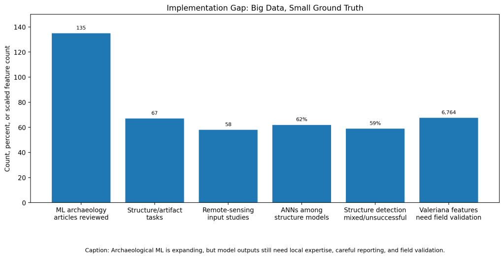
The first gap is ground truth. LiDAR can show a shape, but not automatically tell whether that shape is a house platform, a natural rise, a modern disturbance, a looter’s pit, or a feature from a specific historical period. The Valeriana team said further detailed analysis and field validation were still needed after the remote discovery (Reuters).
The second gap is model transfer. Guyot and colleagues note that archaeological LiDAR interpretation was traditionally expert-based and time-consuming, and that deep CNN methods show promise but remain limited by the need for many training samples and predefined target classes (Guyot et al.).
The third gap is reporting quality. Bellat and colleagues reviewed 135 archaeology machine-learning articles from 1997 to 2022. They found rapid growth after 2019, but also poorly defined requirements, unclear goals, and caveats that were not always communicated well (Bellat et al.).
The fourth gap is that automatic structure detection remains difficult. In the same review, automatic structure detection and artifact classification were the two most common tasks, accounting for 45% of study cases. But automatic structure detection also accounted for many mixed or unsuccessful results, and 59% of structure-detection studies were mainly reported as unsuccessful or partially successful (Bellat et al.).
Section 5: Where It Actually Works
LiDAR works best when it is paired with archaeology, not used instead of archaeology. At Ceibal, researchers combined LiDAR with excavation, architectural chronology, surface collection, and test excavations to interpret social change over time. The LiDAR map made the landscape visible, but the excavation record gave it historical meaning (Inomata et al.).
Machine learning works best as a triage tool. It can flag likely mounds, platforms, terraces, and roads so experts do not start from a blank map. Then archaeologists can prioritize field checks, compare results with known settlement patterns, and refine the model for the local landscape.
Section 6: The Opportunity
The opportunity is not just “finding lost cities.” It is building faster, more complete archaeological maps before sites are damaged by looting, construction, deforestation, or erosion. LiDAR can reveal the hidden landscape. Machine learning can help sort the flood of possible features. Field archaeology can decide what the features actually mean.
The next step is better collaboration between remote-sensing teams and field archaeologists. Models need local training data, uncertainty scores, open reporting standards, and clear documentation of what was verified on the ground. Otherwise, the world gets dramatic headlines about lost cities, but archaeologists still face the same slow question: what did the lasers actually find?
References
[1] Inomata, Takeshi, et al. “Archaeological Application of Airborne LiDAR to Examine Social Changes in the Ceibal Region of the Maya Lowlands.” PLOS ONE, 2018.
[2] Canuto, Marcello A., et al. “Ancient Lowland Maya Complexity as Revealed by Airborne Laser Scanning of Northern Guatemala.” Science, 2018.
[3] Richards-Rissetto, Heather, Devin Newton, and Anwar Al Zadjali. “A 3D Point Cloud Deep Learning Approach Using LiDAR to Identify Ancient Maya Archaeological Sites.” ISPRS Annals, 2021.
[4] Character, Lucas, et al. “Deep Learning for Automatic Structure Detection in Maya LiDAR Data.” 2024.
[5] Britton, Benjamin J., et al. “Evaluating Broadscale Deep Learning for Maya Settlement Detection in G-LiHT Lidar.” Journal of Archaeological Method and Theory, 2026.
[6] Guyot, Alexandre, et al. “Combined Detection and Segmentation of Archaeological Structures from LiDAR Data Using a Deep Learning Approach.” Journal of Computer Applications in Archaeology, 2021.
[7] Bellat, Mathias, et al. “Machine Learning Applications in Archaeological Practices: A Review.” 2025.
[8] Auld-Thomas, Luke, et al. “Running Out of Empty Space: Environmental LiDAR and the Crowded Ancient Landscape of Campeche, Mexico.” Antiquity, 2024.
[9] Reuters. “Lost Mayan City Discovered in Southern Mexico Jungle.” 2024.
[10] Tulane University. “Archaeologists Use LiDAR Technology to Map Wealth and Status in Ancient Maya Society.” 2023.


Leave a Reply