Section 1: The Problem
Coral reefs cover less than 1% of the seafloor, but they support at least 25% of marine species and provide an estimated $2.7 trillion per year in ecosystem services (UNEP). They protect coastlines, support fisheries, drive tourism, and help sustain hundreds of millions of coastal people (UNEP).
The problem is not only that reefs are declining. It is that monitoring them is slow. Traditional reef surveys depend on divers, underwater cameras, expert image labeling, and manual estimates of coral cover. That creates a bottleneck between fieldwork and action. González-Rivero and colleagues describe image analysis as one of the main delays in coral reef reporting, even after digital photography made field collection faster (González-Rivero et al.).
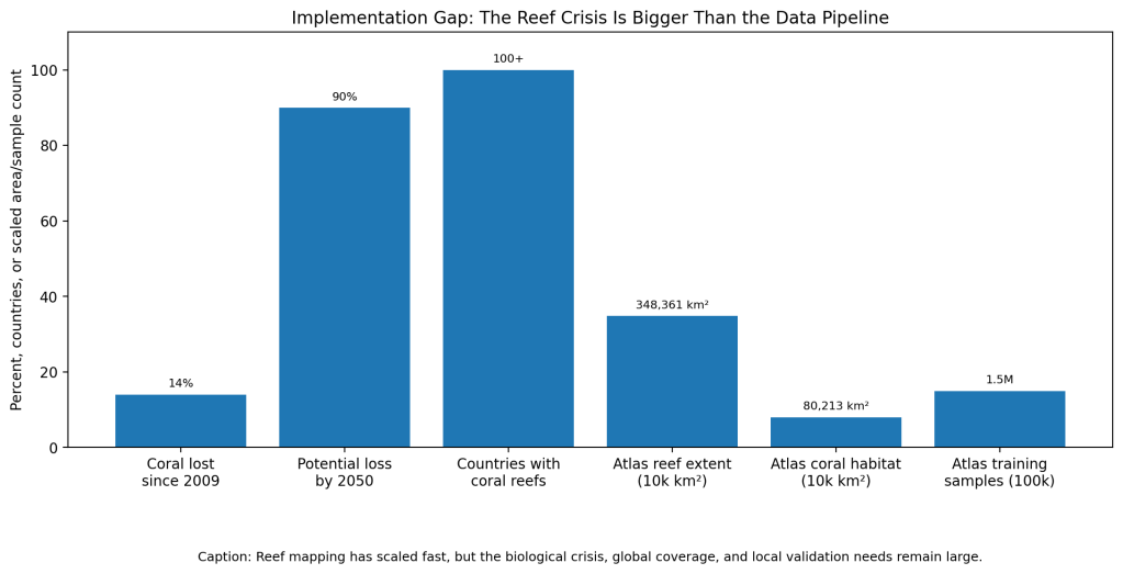
That delay matters because reefs are changing fast. The Global Coral Reef Monitoring Network found that the world lost about 14% of its coral between 2009 and 2018 (UNEP). UNEP also warns that up to 90% of coral reefs could disappear by 2050 even if warming is limited to 1.5°C (UNEP).
Section 2: What Research Shows
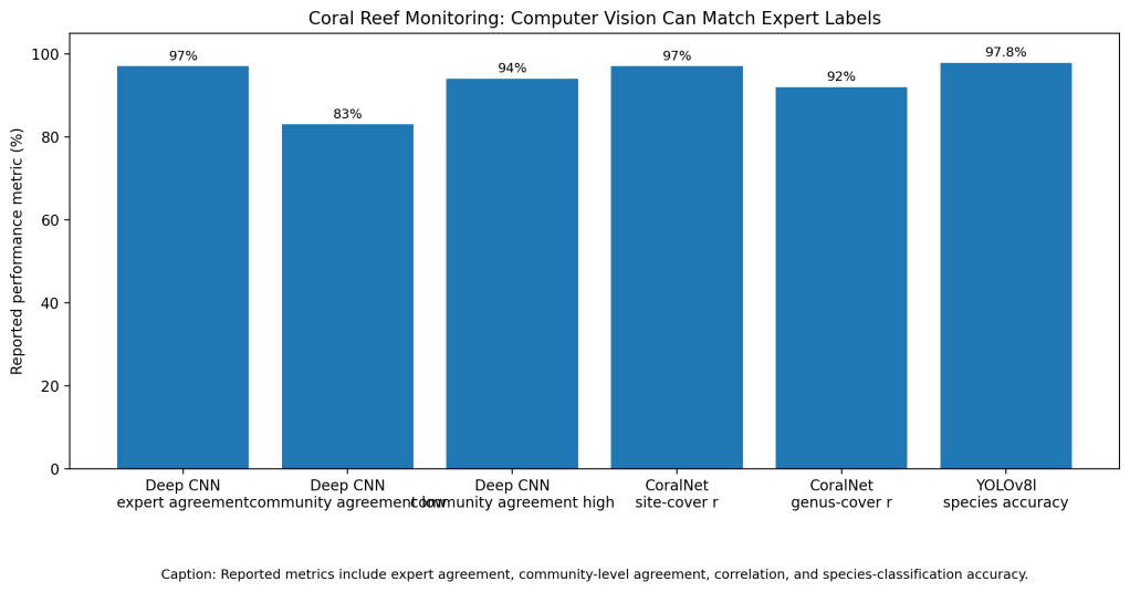
Computer vision can make reef monitoring faster without throwing away scientific rigor. González-Rivero and colleagues tested deep convolutional neural networks on a global coral reef monitoring dataset across five bioregions. The model produced 97% agreement with expert observations, with community-level agreement ranging from 83% to 94% across bioregions (González-Rivero et al.).
CoralNet shows similar promise in an operational research setting. NOAA researchers used imagery from the Pacific Reef Assessment and Monitoring Program and found that CoralNet’s site-level coral cover estimates closely matched human analysts, with Pearson’s r greater than 0.97 and bias of 1% or less. For common coral genera, CoralNet reached Pearson’s r greater than 0.92, with bias of 2% or less in 6 of 7 cases (Williams et al.).
Newer coral species classifiers also perform well on narrow image tasks. Alshahrani and colleagues tested YOLOv5l, YOLOv8l, and VGG16 on 1,187 images of five coral species. YOLOv8l reached 97.8% accuracy (Alshahrani et al.). A 2024 review of coral reef surveillance found machine learning and deep learning are now central tools for reef monitoring, especially image classification and segmentation (Chowdhury et al.).
Section 3: What the Real World Shows
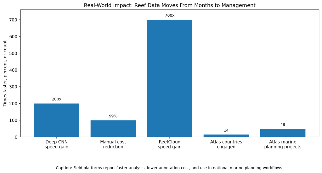
The strongest real-world benefit is speed. González-Rivero and colleagues found automated analysis could accelerate reef image analysis by at least 200 times while reducing analysis cost to about 1% of manual annotation cost (González-Rivero et al.). That changes monitoring from a slow reporting exercise into something closer to real-time environmental intelligence.
ReefCloud shows what this looks like outside one study. The Australian Institute of Marine Science describes ReefCloud as a platform where reef teams upload images, apply automated benthic analysis, and generate standardized outputs for reporting and long-term change detection (AIMS). ICRI reported that ReefCloud analyzes reef composition with 80-90% accuracy and works 700 times faster than traditional manual assessment (ICRI).
The Allen Coral Atlas adds the mapping layer. In 2021, it completed global habitat maps for tropical shallow coral reefs between 30°N and 30°S using satellite imagery, advanced analytics, and object-based analysis (Allen Coral Atlas). A 2024 paper reported 348,361 km² of shallow coral reefs and 80,213 km² of coral habitat, built from more than 1.5 million training samples and over 100 trillion satellite pixels (Lyons et al.).
Section 4: The Implementation Gap
The first gap is local accuracy. A model trained on one reef can struggle on another reef because lighting, water clarity, coral shape, algae, depth, camera angle, and local species all change. NOAA found CoralNet worked well for coral cover, but performance was mixed for some other groups, including algal categories (Williams et al.).
The second gap is data standardization. Reef monitoring programs often use different survey designs, cameras, label categories, and taxonomic detail. AIMS says ReefCloud was built partly to standardize data across regions and organizations because reef imagery is growing faster than traditional workflows can handle (AIMS).
The third gap is coverage. The Allen Coral Atlas is a major breakthrough, but even its high-resolution maps focus on shallow tropical reefs. Lyons and colleagues note the maps estimate shallow reefs and coral habitat, while other reef types, deeper reefs, and turbid-water areas remain harder to map consistently (Lyons et al.).
The fourth gap is turning data into management. A fast map does not automatically stop overfishing, pollution, coastal development, or bleaching. The Allen Coral Atlas blog says officials from 14 countries were engaged with the Atlas team on 48 marine planning projects, which shows impact, but also shows that adoption still depends on government planning, local expertise, and policy follow-through (Allen Coral Atlas).
Section 5: Where It Actually Works
These tools work best when they support reef managers, not replace scientists. ReefCloud works because it combines image upload, automated analysis, standardized outputs, and collaboration across monitoring groups (AIMS). That makes AI part of the monitoring workflow instead of a separate research demo.
The Allen Coral Atlas works because it gives planners a shared map. In Indonesia, Atlas maps helped prioritize 30 million hectares of a new marine protected area and supported decisions about alternative locations for coastal development (Allen Coral Atlas). That is the difference between a model and an operational tool.
Section 6: The Opportunity
The opportunity is not to make reef science look futuristic. It is to make reef data arrive while managers still have time to act. Computer vision can process images faster, satellite maps can show reef extent consistently, and shared platforms can make local monitoring easier to compare across regions.
The next step is better validation. Reef teams need models tested on local images, clear uncertainty scores, human review for difficult labels, and reporting standards that make results comparable. Without that, fast labels can become false confidence. With it, reef monitoring can move from slow reports to faster protection.
References
[1] United Nations Environment Programme. “Coral Reefs.” 2026.
[2] United Nations Environment Programme. “Status of Coral Reefs of the World 2020.” 2021.
[3] González-Rivero, Manuel, et al. “Monitoring of Coral Reefs Using Artificial Intelligence: A Feasible and Cost-Effective Approach.” Remote Sensing, 2020.
[4] Williams, Ivor D., et al. “Leveraging Automated Image Analysis Tools to Better Assess Coral Reefs.” NOAA Fisheries, 2019.
[5] Alshahrani, A., et al. “Classification of Coral Reef Species Using Computer Vision and Deep Learning Techniques.” Engineering, Technology & Applied Science Research, 2024.
[6] Chowdhury, Adyan, et al. “Coral Reef Surveillance with Machine Learning: A Review.” Electronics, 2024.
[7] Australian Institute of Marine Science. “ReefCloud.” 2026.
[8] International Coral Reef Initiative. “ReefCloud: Open Access Tool Launched for Fast, Accurate Reef Data.” 2022.
[9] Lyons, Mitchell B., et al. “New Global Area Estimates for Coral Reefs from High-Resolution Mapping.” Cell Reports Sustainability, 2024.
[10] Allen Coral Atlas. “Allen Coral Atlas Completes First Global Coral Reef Maps.” 2021.

Leave a comment