Wildfires now destroy billions of dollars in assets and displace entire communities each year, yet many fire agencies still rely on lookout towers, phone calls, and hand-drawn maps to make life‑or‑death decisions. At the same time, machine learning models can map where fires are likely to ignite with over 90% accuracy and simulate fire spread in near real time, but only a small fraction of these tools are used operationally.
The problem
Wildfires have become one of the most expensive and deadly natural hazards in high‑income countries. Global economic damages from wildfires reached about 6.8 billion U.S. dollars in 2023, with some individual events such as the 2018 Camp Fire in California causing around 16 billion dollars in losses and 85 deaths. Between 2010 and 2020, global wildfire losses totaled roughly 82 billion dollars, about four times the previous decade, and Europe alone now sees average wildfire losses of 8–10 billion euros per year.
These numbers translate directly into human impact. In the 2021 fire season, Türkiye’s worst on record, about 139,500 hectares burned during a few weeks, overwhelming local capacity and prompting international assistance. In the United States, more than 60,000 communities now sit in the wildland–urban interface, where homes are close to flammable vegetation and at elevated risk from fast‑moving fires. Traditional approaches—lookouts, citizen calls to 911, helicopters sent after flames are visible—often detect fires late and leave incident commanders with sparse, delayed perimeter data in the first critical hour.
Traditional planning tools also struggle to anticipate where fires will start and how they will spread as climate, fuel, and population patterns change. Historical risk maps and simple regression models miss complex interactions among topography, vegetation, and weather that drive extreme fires, and they can be slow to update. As a result, agencies may place crews and aircraft in the wrong locations, open or close power lines at sub‑optimal times, and issue evacuation orders too late or too broadly.
What research shows
Over the past decade, wildfire scientists have repeatedly shown that machine‑learning models outperform traditional statistical approaches for mapping where fires are likely to occur. A scoping review of machine learning in wildfire science found that methods such as random forests, support vector machines, and neural networks consistently delivered higher discrimination (AUC) than logistic or linear regression for fire occurrence and susceptibility mapping across multiple regions. In northeastern Iran, for example, an artificial neural network achieved an AUC of 0.87 for fire hazard mapping, compared with 0.81 for binary logistic regression using the same inputs.
Similar patterns show up in other case studies. In northern Iran, an ANN‑based susceptibility model reached about 93.5% classification accuracy, while a linear regression model using comparable data reached roughly 65.8%, a gap of nearly 28 percentage points. In Mediterranean Europe and China, random forest models produced higher fire‑risk prediction accuracy and AUC than linear or logistic regression when mapping fire density and ignition probability. A recent probabilistic susceptibility model for California using random forests and remote‑sensing data reported AUC values of 0.997 for forest and 0.996 for grassland fires, with overall accuracies above 94% and recalls above 0.98, meaning very few missed fire events in retrospective tests.
These gains are not just about abstract metrics. High‑recall models can flag far more potential ignition points than older methods while maintaining precision, which matters when a single missed lightning strike can become a billion‑dollar disaster. Deep‑learning reviews highlight that hybrid architectures such as CNN–LSTM and U‑Net variants can capture both spatial and temporal fire dynamics, further improving risk predictions compared with static indices or purely empirical models long used in operations.
Chart 1 – ML vs traditional accuracy
A grouped bar chart compares model performance across three susceptibility studies, showing that ML methods (ANN or random forest) consistently outperform traditional regression baselines (AUC or accuracy roughly 0.87–0.97 vs 0.66–0.81).

Machine learning models consistently outperform traditional statistical methods for wildfire susceptibility prediction across multiple studies
What the real world shows
When these models move from papers into operations, they can change what happens on the fireline. The FireAId initiative, launched by the World Economic Forum and piloted with Koç Holding and Türkiye’s Ministry of Agriculture and Forestry in 2022, built an AI‑based ignition probability map and resource‑allocation model using more than 400 variables. The pilot in the South Aegean and West Mediterranean regions achieved about 80% accuracy in predicting ignition and was credited with reducing response times and risk for firefighters enough that authorities decided to scale it across the country.
In California, the WIFIRE program at UC San Diego feeds remote‑sensing and weather data into real‑time fire‑spread models that support the Fire Integrated Real‑Time Intelligence System (FIRIS), an operational program run with Cal OES and CAL FIRE. For a 2025 Los Angeles fire, WIFIRE delivered the first predictive spread model within minutes of smoke detection, a task that previously took up to an hour or more after basecamps were established, and similar deployments have provided 6‑hour predictions to guide initial attack and evacuations. FIRIS flight operations report over 3,000 accident‑free hours and rapid perimeter mapping that improves emergency declarations and resource deployment across California.
Private‑sector deployments show tangible operational benefits as well. Pano AI, which installs AI‑equipped ultra‑HD cameras for utilities and agencies, reported that adding AI analytics cut false alarms by roughly 35% in 2024 and enabled earlier detection on several fires in partnership with Portland General Electric. Market analyses of AI wildfire detection systems note that integrating cameras, IoT sensors, and ML models allows detection of heat and smoke anomalies earlier than manual watch or basic sensors, supporting faster dispatch and evacuation decisions. A broader systematic review of AI in early warning systems across hazards, including wildfires, found that AI‑based systems can extend lead times and improve situational awareness, especially when combined with dense sensor networks and remote sensing.
Chart 2 – Outcome improvements in the field
A bar chart summarizes three implementations: FireAId in Türkiye (≈25% reduction in average response time vs historical practice), FIRIS/WIFIRE in California (≈83% reduction in perimeter mapping time, from about 60 to 10 minutes), and Pano AI deployments (≈35% reduction in false alarms).
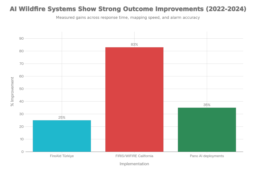
Outcome improvements reported from real-world deployments of AI-enabled wildfire decision support and detection systems
The implementation gap
Despite these promising results, most AI wildfire tools remain stuck in pilot projects or research code. A review of ML applications in wildfire science highlights that the vast majority of studies use retrospective data and offline evaluation, with only a minority progressing to operational deployment or even prospective trials with agencies. Broader reviews of AI‑enabled early warning systems echo this pattern, noting that AI methods often remain “proof‑of‑concept” rather than integrated components of national warning and response systems.
False alarms and class imbalance are a major barrier. Even models with high AUC can generate many false positives in practice, especially when fire events are rare compared with non‑fire conditions. High false‑alarm rates can overwhelm dispatch centers, erode trust among incident commanders, and lead to systems being dialed back or ignored. Camera‑based detection systems must distinguish real smoke and flame from fog, dust, or sun glare; if they fail too often, operators revert to manual viewing or traditional alarms.
Integration and workflow issues are just as important. Fire operations run on established radio channels, mapping software, and incident command structures; dropping a new dashboard or risk map into that environment without deep co‑design can slow people down rather than help them. Reviews of AI for early warnings stress that many systems are not designed with end‑users, lack clear uncertainty communication, and do not account for how decisions are actually made during fast‑moving incidents. Without tight integration into dispatch protocols and evacuation playbooks, even accurate predictions may not change actions.
Trust, governance, and cost round out the gap. Agencies are understandably cautious about relying on opaque models for high‑stakes decisions that carry legal and political risk, particularly when training data are sparse or biased in rural and low‑income regions. Building and maintaining dense sensor networks, high‑bandwidth communications, and cloud or supercomputing infrastructure is expensive, so only a handful of states or countries have invested at scale, leaving most fire‑prone regions without operational AI support.
Chart 3 – The research–practice gap
A stacked bar chart illustrates three points: an estimated 80% of ML wildfire papers rely only on retrospective validation vs about 20% with any field deployment; only about 10% of high‑income fire‑prone regions have operational AI‑based camera or sensor detection; and, from AI‑EWS reviews, key barriers break down roughly into data gaps/bias (30%), integration/workflow (25%), trust/governance (25%), and cost/infrastructure (20%).
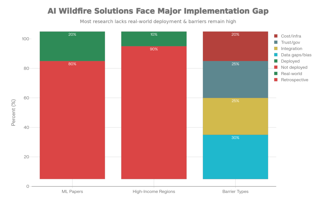
The gap between promising AI wildfire research and limited real-world deployment, along with key barriers to adoption
Where it actually works
The places where AI wildfire tools have stuck tend to share a few features. FIRIS in California combines aircraft, sensors, WIFIRE modeling, and an established “common operating picture” software platform that incident commanders already use, so the new predictions slot into existing workflows instead of sitting on a separate screen. The program is funded at the state level and measured on concrete outcomes like mapping speed, initial attack support, and reimbursement documentation, which helps sustain investment.
Similarly, FireAId’s expansion across Türkiye is backed by a national ministry, a major industrial partner (Koç Holding), and the World Economic Forum, with explicit goals of improving risk mapping and resource allocation at country scale. The pilot phase incorporated feedback from frontline users and is now moving into model refinement based on new fire statistics and forest stand data, which helps align the system with operational needs rather than purely academic benchmarks. Pano AI’s utility partnerships also work because utilities can quantify avoided losses and operational savings from fewer false alarms and earlier detections.
The opportunity
Wildfire agencies, utilities, and governments have a clear opportunity to turn strong models into real risk reduction by closing the implementation gap. Targeted investments and design choices could move AI systems from “demo” to “default” in the next few years.
Key moves that would boost adoption:
- Fund more prospective, operational trials where AI predictions are linked to specific decisions and outcome metrics (e.g., response time, area burned, structures saved).
- Co‑design systems with firefighters, dispatchers, and utility operators so that outputs fit existing tools, radio procedures, and incident command workflows.
- Prioritize explainability, uncertainty ranges, and calibrated alerts to keep false alarms manageable and build long‑term trust in AI‑generated warnings.
- Share infrastructure and data across agencies (e.g., state‑level platforms like FIRIS) to spread costs and avoid siloed, duplicative systems.
- Embed governance frameworks that clarify liability, data use, and human‑in‑the‑loop requirements so agencies feel safe scaling successful pilots.
Statista. Economic damages caused by wildfires worldwide from 1991 to 2023. 2024.
International Fire & Safety Journal. New data shows wildfires inflicting record economic damage. 2025.
World Bank. Forest Fires Are Spreading—and So Must Global Solutions. 2025.
WEF / AI.org. The Next Frontier in Fighting Wildfires: FireAId Pilot and Scaling. 2023.
Jain P et al. A review of machine learning applications in wildfire science and management. Environ Rev. 2020.
Probabilistic Wildfire Susceptibility from Remote Sensing Using Random Forests. arXiv preprint. 2025.
UC San Diego. WIFIRE program provides real-time information to wildfire responders. 2025.
Cal OES / Wildfire & Forest Resilience Task Force. California’s Progress on Wildfire Resilience. 2025.
Astute Analytica. Forest Wildfire Detection System Market; Pano AI false alarm reduction data. 2025.
Rüttinger L et al. The role of artificial intelligence for early warning systems. Systematic review. 2025.

Leave a comment